Analyseergebnisse
Die KI hat anhand des Bildes, sichtbarer Details und kontextueller Hinweise die wahrscheinlichsten Orte gewaehlt.
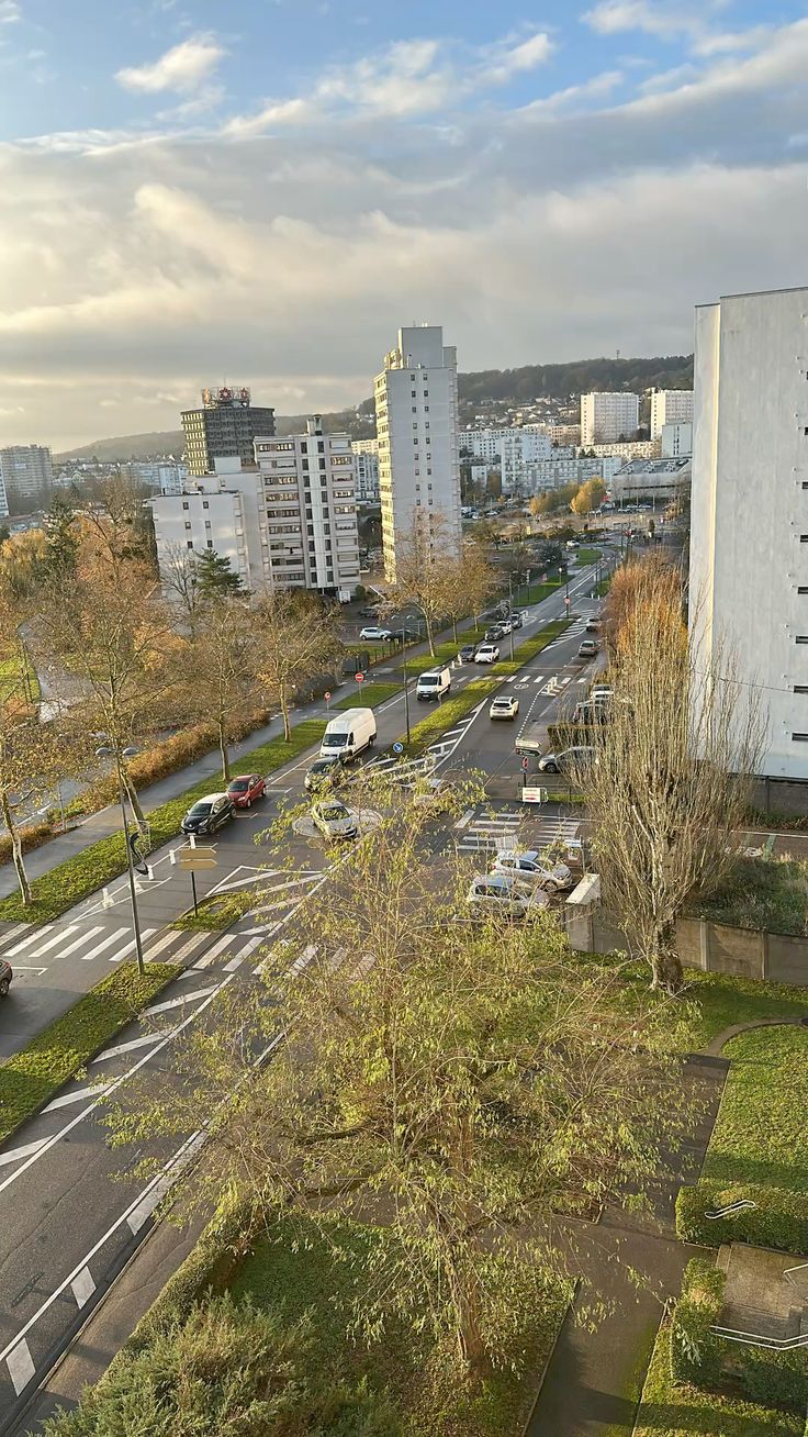
The image displays several strong indicators pointing to Rouen, France. The most prominent is the dark, tall building with a distinctive structure on its roof visible in the far distance on the left side of the image, which is identifiable as the Tour des Finances (also known as Tour de la Sécurité Sociale) located at 2 Rue de la Mare du Parc.
The tall white building on the right with vertical window strips matches the building at 10 Rue de la Mare du Parc. The tall white building in the middle-left with numerous small square windows corresponds to 20 Rue de la Mare du Parc.
The road itself, with its central median, white dashed lane markings, and the small roundabout, perfectly matches the layout of Rue de la Mare du Parc, looking northeast from an elevated position. The hilly background is consistent with the topography of Rouen, particularly the Côte Sainte-Catherine area.
The general architecture of the apartment blocks and the style of road signs (e.g., red circular 'no stopping/parking' type, blue circular 'mandatory direction', yellow diamond 'priority road') are typical for France and European standards. The image shows a typical French suburban residential area with mid-rise apartment buildings and road markings consistent with France (white dashed lines, pedestrian crossings, and roundabout signs).
The architecture style and urban planning resemble Strasbourg's Neuhof or Cronenbourg districts, which have similar terrain and building density. The hill with forest in the background matches the topography south of Strasbourg.
The presence of autumn leaf colors suggests a temperate climate typical of northeastern France. The road layout with roundabouts and parking also fits Strasbourg's suburban design.
The image shows a typical French suburban residential area with mid-rise apartment buildings and road markings consistent with France (white dashed lines, pedestrian crossings, and roundabout signs). The architecture style and urban planning resemble Strasbourg's Neuhof or Cronenbourg districts, which have similar terrain and building density. The hill with forest in the background matches the topography south of Strasbourg. The presence of autumn leaf colors suggests a temperate climate typical of northeastern France. The road layout with roundabouts and parking also fits Strasbourg's suburban design.
🗺 Auf der Karte
 высокая уверенность
•
высокая уверенность
•
 средняя
•
средняя
•
 низкая
Wie die KI ihre Entscheidung getroffen hat
Umgebung
Hilly in the background, urban flatland in the foreground • Deciduous trees (mostly bare, indicating late autumn/early winter), grass, evergreen bushes • Temperate • gently hilly urban area • deciduous trees in autumn
Infrastruktur
White dashed lane lines, solid white edge lines, white zebra crossings, white diagonal hatching for roundabout approach • European standard (red circular, blue circular, yellow diamond signs) • Post-war functionalist/modernist apartment blocks, some taller towers • white dashed lines, pedestrian crossings, roundabout signs • European style, likely French • mid-rise concrete apartment blocks typical of French suburbs
Sichtbarer Text und Schilder
Die KI hat keinen lesbaren Text oder Beschilderung erkannt.
Kontext und Kultur
Predominantly European car models (hatchbacks, sedans, white vans) • Not clearly visible, but consistent with European plates • passenger cars, vans • European style, white plates