Analyseergebnisse
Die KI hat anhand des Bildes, sichtbarer Details und kontextueller Hinweise die wahrscheinlichsten Orte gewaehlt.
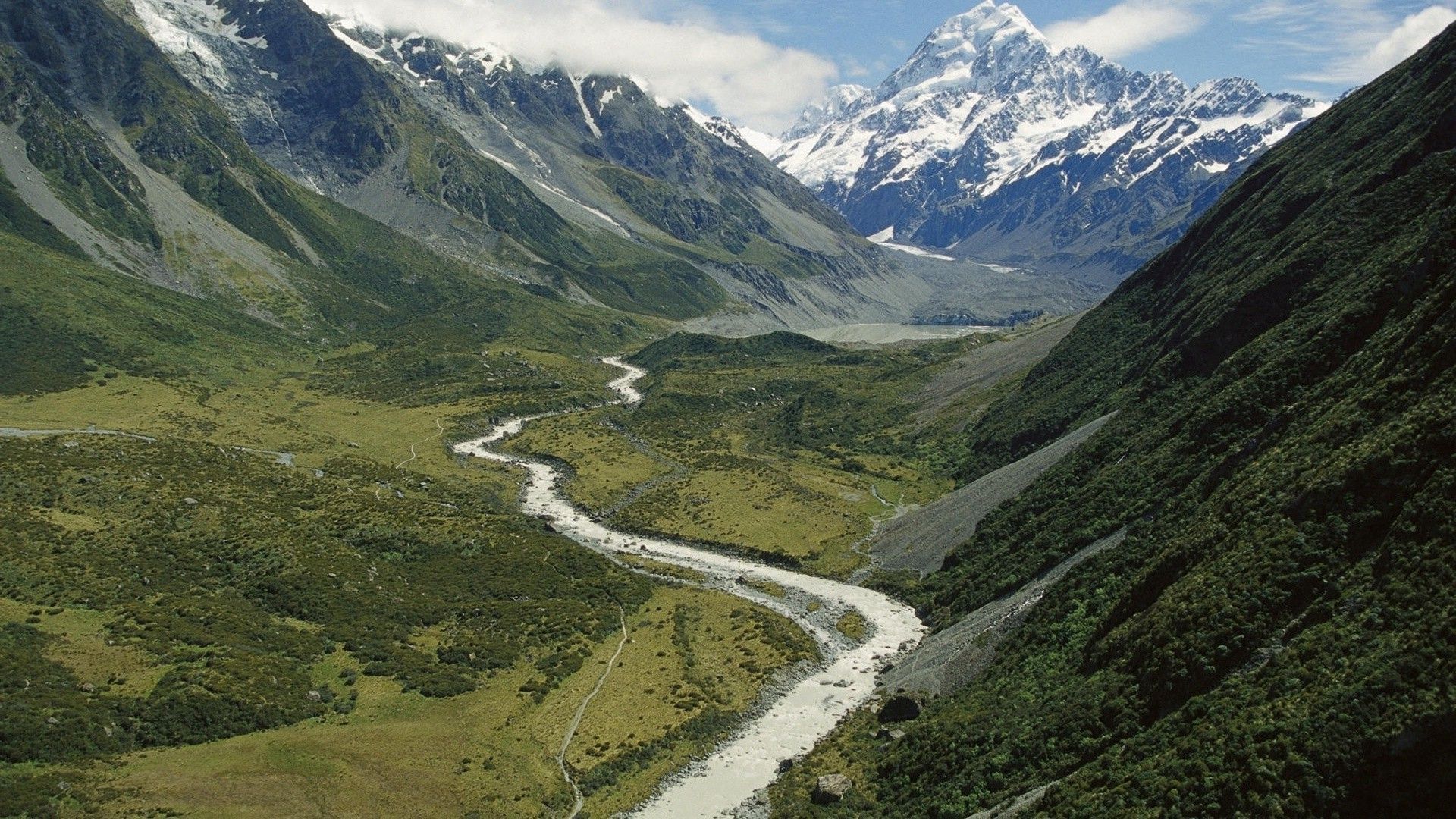
The image displays an unmistakable and iconic view of Aoraki / Mount Cook, the highest mountain in New Zealand. The prominent pyramidal, snow-capped peak is the key identifier.
The landscape features a classic U-shaped glacial valley, through which a milky, sediment-laden river (the Hooker River) meanders. This milky appearance is characteristic of glacial meltwater carrying fine rock flour.
A well-defined hiking path, the Hooker Valley Track, is visible running parallel to the river. The vegetation, consisting of tussock grasslands and low alpine scrub on the valley floor with patches of dark green forest on the slopes, is typical of New Zealand's Southern Alps.
The combination of these specific geographical features provides a definitive match for the Hooker Valley within Aoraki/Mount Cook National Park. The image shows a prominent snow-capped peak with a glacier and a braided river valley, typical of the Southern Alps in New Zealand.
The mountain in the background closely resembles Aoraki / Mount Cook, the highest peak in New Zealand. The terrain, vegetation, and glacier features match the Hooker Valley area near Mount Cook Village in the Mackenzie District.
This is a well-known hiking and scenic area with trails following the river valley visible in the image. This is a highly speculative alternative.
The landscape shares some general characteristics with the Patagonian Andes, such as U-shaped glacial valleys, jagged granite peaks, and extensive hiking trail systems. The Valle del Francés in Torres del Paine National Park is one such example.
However, the specific morphology of the main peak in the image does not match any of the famous peaks in Torres del Paine (like the Torres or Cuernos), and the vegetation, while similar, differs in composition from the classic New Zealand tussock grasslands. Another speculative alternative based on broad similarities.
The Canadian Rockies feature numerous glacial valleys with prominent peaks and milky-blue rivers and lakes. The Valley of the Ten Peaks is a famous example.
However, the geology of the Canadian Rockies often displays distinct sedimentary layers, which are not apparent on the main peak in the image. Furthermore, the vegetation in the valleys is dominated by coniferous forests (pine, fir, spruce), which looks different from the mix of tussock and scrub seen in the photo.
The image shows a prominent snow-capped peak with a glacier and a braided river valley, typical of the Southern Alps in New Zealand. The mountain in the background closely resembles Aoraki / Mount Cook, the highest peak in New Zealand. The terrain, vegetation, and glacier features match the Hooker Valley area near Mount Cook Village in the Mackenzie District. This is a well-known hiking and scenic area with trails following the river valley visible in the image.
This is a highly speculative alternative. The landscape shares some general characteristics with the Patagonian Andes, such as U-shaped glacial valleys, jagged granite peaks, and extensive hiking trail systems. The Valle del Francés in Torres del Paine National Park is one such example. However, the specific morphology of the main peak in the image does not match any of the famous peaks in Torres del Paine (like the Torres or Cuernos), and the vegetation, while similar, differs in composition from the classic New Zealand tussock grasslands.
Another speculative alternative based on broad similarities. The Canadian Rockies feature numerous glacial valleys with prominent peaks and milky-blue rivers and lakes. The Valley of the Ten Peaks is a famous example. However, the geology of the Canadian Rockies often displays distinct sedimentary layers, which are not apparent on the main peak in the image. Furthermore, the vegetation in the valleys is dominated by coniferous forests (pine, fir, spruce), which looks different from the mix of tussock and scrub seen in the photo.
🗺 Auf der Karte
 высокая уверенность
•
высокая уверенность
•
 средняя
•
средняя
•
 низкая
Wie die KI ihre Entscheidung getroffen hat
Umgebung
High-alpine glacial valley with steep, scree-covered slopes and jagged, snow-capped peaks. • Tussock grassland, alpine scrub, and patches of dense temperate forest. • Alpine / Temperate • Alpine valley with glacier and braided river • Alpine tussock and shrubland • Temperate alpine • Glacial valley with high granite peaks. • Southern beech (Lenga) forests and scrubland. • Subpolar oceanic / Alpine • Glacial valley surrounded by high, layered-rock peaks. • Coniferous forest (pine, spruce, fir). • Subarctic / Alpine
Infrastruktur
Not applicable • None visible
Sichtbarer Text und Schilder
Die KI hat keinen lesbaren Text oder Beschilderung erkannt.
Kontext und Kultur
None visible • Not applicable