Resultados da analise
A IA selecionou os locais mais provaveis com base na imagem, detalhes visiveis e contexto.
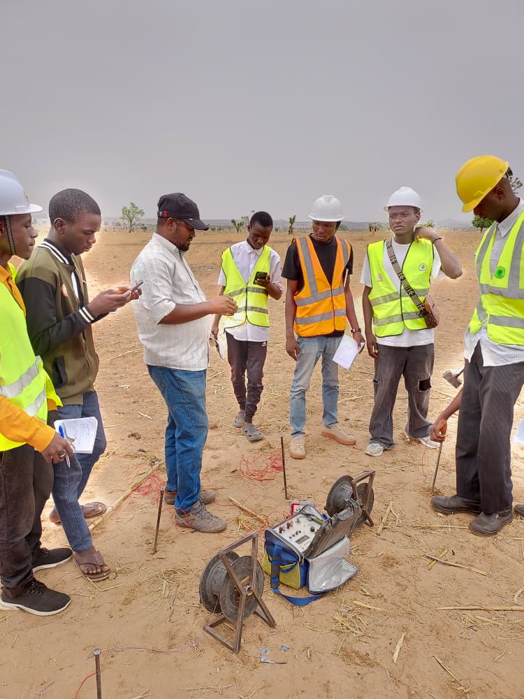
The dry, dusty environment with sparse small trees and scrub vegetation, combined with the appearance of the people and their clothing style, suggests a West African Sahelian environment. The equipment and activity resemble geophysical or engineering fieldwork common in developing regions.
The overall setting and demographic point to Mali near Bamako, where such surveys are common for infrastructure projects. The image shows a group of Black African men conducting what appears to be a geophysical survey (specifically, electrical resistivity) in a rural setting.
The environment is a flat, semi-arid savanna with sandy soil, dry grass, and sparse trees, which is highly characteristic of the Sahel and Sudan Savanna belts of West Africa. Northern Nigeria fits this description perfectly.
Furthermore, Nigeria's large population and numerous universities with geology and engineering departments (like Ahmadu Bello University in Zaria) make it a very likely location for such academic or professional fieldwork. The combination of ethnicity, climate zone, and specific activity points strongly to this region.
The landscape and ethnicity of the people are also a perfect match for southern Niger, which borders northern Nigeria and shares a similar environment and culture. The arid conditions make groundwater exploration, the likely purpose of the equipment shown, a critical and common activity.
Visually, this location is nearly indistinguishable from northern Nigeria, making it a strong alternative candidate. The scene is also highly consistent with the landscape of Burkina Faso, particularly the central plateau around the capital, Ouagadougou.
The country lies squarely within the Sahelian and Sudanian savanna zones. The type of fieldwork depicted is common for academic institutions and NGOs operating in the country.
This represents another plausible location within the broader West African region suggested by the primary evidence.
The image shows a group of Black African men conducting what appears to be a geophysical survey (specifically, electrical resistivity) in a rural setting. The environment is a flat, semi-arid savanna with sandy soil, dry grass, and sparse trees, which is highly characteristic of the Sahel and Sudan Savanna belts of West Africa. Northern Nigeria fits this description perfectly. Furthermore, Nigeria's large population and numerous universities with geology and engineering departments (like Ahmadu Bello University in Zaria) make it a very likely location for such academic or professional fieldwork. The combination of ethnicity, climate zone, and specific activity points strongly to this region.
The landscape and ethnicity of the people are also a perfect match for southern Niger, which borders northern Nigeria and shares a similar environment and culture. The arid conditions make groundwater exploration, the likely purpose of the equipment shown, a critical and common activity. Visually, this location is nearly indistinguishable from northern Nigeria, making it a strong alternative candidate.
The scene is also highly consistent with the landscape of Burkina Faso, particularly the central plateau around the capital, Ouagadougou. The country lies squarely within the Sahelian and Sudanian savanna zones. The type of fieldwork depicted is common for academic institutions and NGOs operating in the country. This represents another plausible location within the broader West African region suggested by the primary evidence.
🗺 No mapa
 высокая уверенность
•
высокая уверенность
•
 средняя
•
средняя
•
 низкая
Como a IA tomou a decisao
Ambiente
flat, dry, semi-arid • sparse small trees and scrub • hot, dry • Flat plain • Dry grass, sparse savanna trees • Semi-arid / Tropical savanna • Flat, sandy plain • Sparse, dry grass and scrubland trees • Semi-arid (Sahel) • Flat savanna • Dry grass and savanna trees • Tropical savanna
Infraestrutura
none visible • None
Texto visivel e placas
A IA nao detectou texto legivel ou sinalizacao na imagem.
Contexto e cultura
none visible