Analyseergebnisse
Die KI hat anhand des Bildes, sichtbarer Details und kontextueller Hinweise die wahrscheinlichsten Orte gewaehlt.
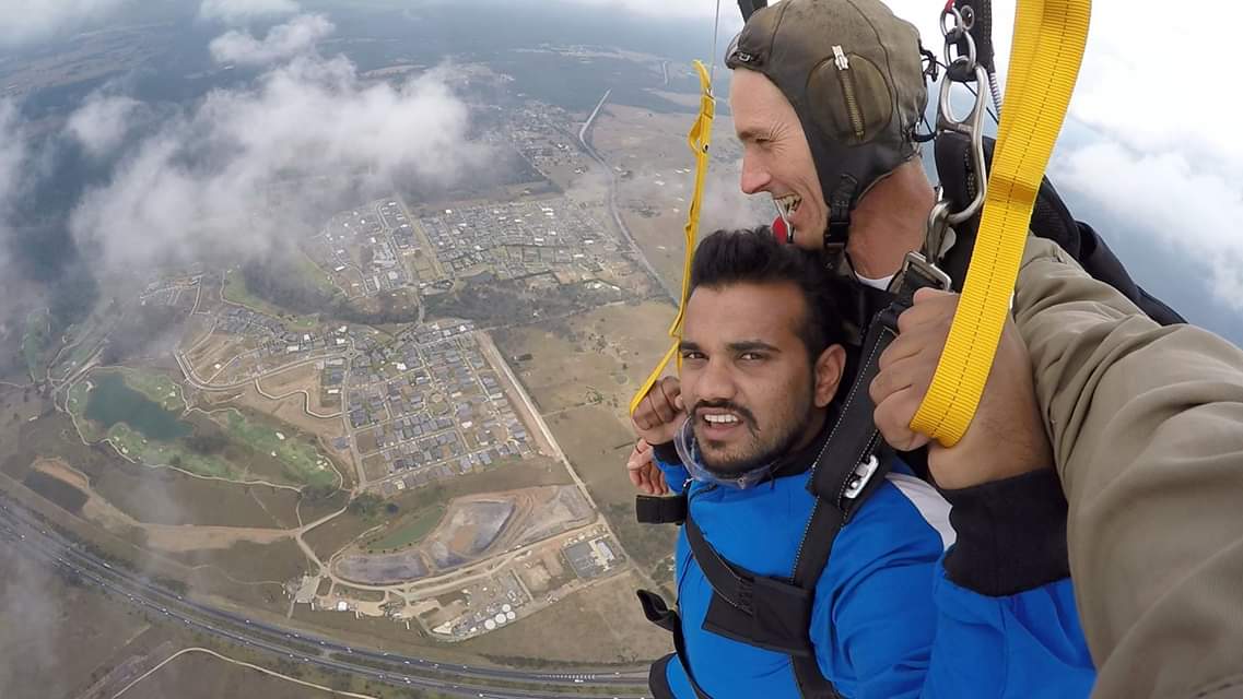
The image provides a clear aerial view of a landscape featuring a prominent multi-lane highway with a wide median, a large golf course with a distinctive lake, and extensive modern suburban housing developments. The highway at the bottom left of the image is identifiable as the M7 Motorway (Westlink M7) in Western Sydney, Australia, due to its characteristic width, number of lanes, and wide median.
Adjacent to the highway, the golf course with its large, irregularly shaped lake and specific layout of fairways perfectly matches the Stonecutters Ridge Golf Club. The surrounding residential areas, particularly to the east and north of the golf course, correspond to the rapidly developing suburbs of Colebee and Marsden Park, which feature new, detached single-story homes typical of Australian suburban expansion.
The patches of bushland and the overall terrain are also consistent with the Western Sydney region. The combination of these unique features allows for a precise match to this specific location.
The landscape shows a semi-arid environment with sparse vegetation and a layout of roads and residential areas typical of suburban Johannesburg. The highway visible is a major route consistent with Gauteng's road infrastructure.
The presence of a golf course and the style of housing clusters match known suburban developments around Johannesburg, such as areas near Midrand or Centurion. The skydiving activity is common in this region, which has several drop zones near Johannesburg.
The landscape shows a semi-arid environment with sparse vegetation and a layout of roads and residential areas typical of suburban Johannesburg. The highway visible is a major route consistent with Gauteng's road infrastructure. The presence of a golf course and the style of housing clusters match known suburban developments around Johannesburg, such as areas near Midrand or Centurion. The skydiving activity is common in this region, which has several drop zones near Johannesburg.
🗺 Auf der Karte
 высокая уверенность
•
высокая уверенность
•
 средняя
•
средняя
•
 низкая
Wie die KI ihre Entscheidung getroffen hat
Umgebung
Gently rolling, developed land • Mix of manicured golf course, suburban landscaping, and patches of Australian bushland/forest • Temperate, with visible clouds suggesting a potentially humid or overcast day • semi-arid, flat to gently rolling • sparse grassland, few trees • temperate, dry
Infrastruktur
Clear multi-lane highway markings, well-defined suburban road network • Not discernible from altitude • Modern, detached single-family homes in suburban style; some larger commercial/industrial buildings visible near the highway • divided highway with multiple lanes • none visible • modern suburban housing clusters
Sichtbarer Text und Schilder
Die KI hat keinen lesbaren Text oder Beschilderung erkannt.
Kontext und Kultur
Cars and trucks (as small dots on highway) • Not discernible from altitude • none visible